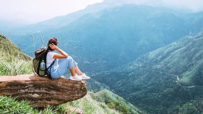
Lakegala, located in the village of Meemure in the Knuckles mountain range, is renowned for its striking triangular shape and towering presence. The mountain, which stands at approximately 1,310 meters high, is often referred to as "The Rock of Lanka" due to its significant height and prominent bare rock outcrop.
The hike to Lakegala is considered one of the most challenging in Sri Lanka, particularly the route from Meemure, which requires expert climbing skills and appropriate gear. The last 300 meters of the ascent are especially difficult, necessitating ropes and careful navigation? (Hii Travellers)?? (lovidhu.com)?. Despite these challenges, the climb offers breathtaking views of the surrounding landscape, including the eastern coast of Sri Lanka and the lush vegetation of the Knuckles Range? .
The area around Lakegala is rich in legend and history. One popular legend suggests that King Ravana ruled his kingdom from the summit of Lakegala. Another legend holds that Lord Buddha left his footsteps on the peak during his third visit to Sri Lanka.
To reach Lakegala, travelers can take the A9 road from Matale to Kandy, then proceed to Meemure. The best time to hike is during the dry months of August and September, when the trails are less slippery and the weather is favorable? (Hii Travellers)?. It is strongly advised to undertake the climb with a local guide to ensure safety and proper navigation of the trails.
附近地点
约 25 公里范围内的 15 个地点,由近及远。
- Dumbara Ella Falls2 公里
- Alakola Falls4 公里
- 坎贝尔小径森林保护区4 公里
- Sembuwatta Lake4 公里
- Nitro Cave4 公里
- Corbet’s Gap6 公里
- Gommolliya Peak6 公里
- Knuckles Viewpoint7 公里
- Rathna Ella Falls7 公里
- Kaluwa Watuna Ella7 公里
- Pitawala Pathana (Mini World's End)8 公里
- Randenigala Dam11 公里
- Seetha Kotuwa11 公里
- Sera Ella Falls11 公里
- Riverston Peak17 公里
相关阅读
1 个相关主题页面。